
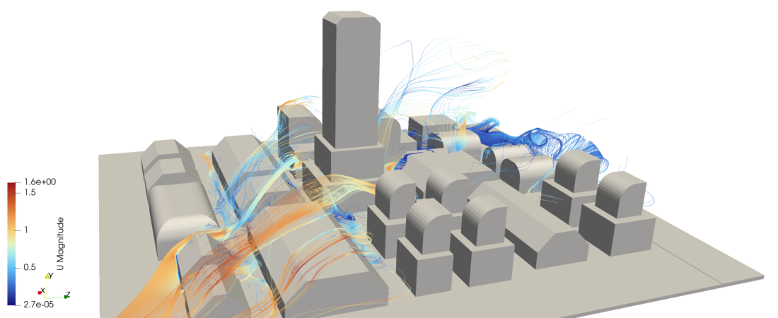
Urban microclimates and ground-level pedestrian comfort are critical considerations in modern landscape architecture, civil engineering, and sustainable city planning. As metropolitan areas densify and vertical high-rise clusters expand, buildings act as massive bluff bodies that obstruct and drastically redirect natural atmospheric wind fields. If urban layouts are engineered without analyzing these aerodynamic interactions, they can create severe safety and commercial liabilities. For instance, high-speed structural downwashes can generate gale-force wind tunnels at street intersections that endanger elderly pedestrians, while poorly ventilated street canyons can trap vehicle exhaust and accelerate the urban heat island effect. Computational Fluid Dynamics (CFD) provides urban planners with a high-fidelity digital wind tunnel to visualize complex aerodynamic wakes, analyze ground-level wind comfort, and refine city grids with high precision.
Technical and Theoretical Description
From an aerodynamic perspective, urban microclimate modeling operates on unconfined, high Reynolds number external fluid dynamics governed by the three-dimensional, incompressible Navier-Stokes equations and atmospheric boundary layer (ABL) kinematics. Wind approaching an urban center is defined by a non-uniform velocity profile where wind speed increases logarithmically with altitude, mathematically described via a plain-text logarithmic or power-law profile function calibrated to the upstream terrain roughness. Because wind navigating dense city blocks generates intense flow separation, adverse pressure gradients, and highly chaotic wake vortices, steady-state approximations are frequently insufficient. While the Reynolds-Averaged Navier-Stokes (RANS) Realizable k-epsilon or Shear Stress Transport (k-omega SST) models are deployed for baseline wind-loading and pressure mapping, transient Large Eddy Simulation (LES) or Detached Eddy Simulation (DES) is increasingly utilized to resolve high-frequency wind gusts that dictate real-world pedestrian mechanical stability.
The primary theoretical focus in urban planning simulations is the quantitative evaluation of pedestrian wind comfort and safety metrics across all walkable surfaces. Localized wind velocities are extracted at a standardized pedestrian height of 1.5 meters above the ground and evaluated against globally recognized comfort criteria, such as the Lawson, Davenport, or Dutch NEN 8100 standards. These frameworks combine local historical meteorological data with CFD velocity amplification factors to determine exceedance frequencies for plain-text velocity thresholds. For example, a plaza is graded for “long-term sitting” (outdoor cafes) if wind speeds remain under 4 meters per second for 95% of the year, whereas speeds exceeding 15 meters per second trigger strict safety alarms for walking stability. Concurrently, to evaluate environmental air quality within street canyons, a passive scalar species transport equation is solved to track the dispersion, residence time, and dilution rates of traffic-generated air pollutants over time.
Business Value of CFD Implementation
From a commercial and regulatory standpoint, integrating CFD into early-stage urban planning yields massive capital expenditure (CapEx) savings and directly accelerates project approval lifecycles. Many progressive municipal planning commissions legally mandate comprehensive ground-level wind assessments before issuing building permits for structures exceeding specific height thresholds. Historically, verifying a development’s wind impact required manufacturing highly detailed physical scale models and booking weeks of expensive testing inside specialized boundary-layer wind tunnels. CFD serves as a rapid virtual staging ground, enabling developers to demonstrate safety compliance, resolve wind issues digitally, and secure municipal planning permissions months faster, dramatically reducing carrying costs on high-value real estate.
In terms of ongoing operational and property value, an aerodynamically refined urban blueprint directly enhances corporate revenue and public space utility. Eliminating high-velocity downwashes and corner acceleration zones transforms harsh, uninviting concrete walkways into pleasant, vibrant microclimates. This unlocks the full commercial potential for high-revenue outdoor retail, pedestrian shopping districts, and open-air dining plazas, driving up property lease rates and premium tenant yields. Furthermore, by utilizing favorable building pressure distributions discovered via CFD, planners can optimize natural ventilation paths through urban corridors, reducing localized ambient temperatures, combatting the urban heat island effect, and lowering the baseline HVAC energy demands of the surrounding building envelopes.
Challenges of CFD in Urban Microclimate Modeling
Despite its immense analytical power, simulating an active urban microclimate introduces steep multi-scale physical and numerical challenges. The foremost obstacle is the extreme discrepancy in spatial scales combined with massive geometric complexity. A typical urban CFD domain must stretch across several kilometers upstream and downstream to capture realistic atmospheric boundary layer development and the blocking effects of neighboring topography, yet the simulation must simultaneously resolve millimeter-scale architectural features—such as structural canopies, podium set-backs, louvers, and balconies—that heavily dictate local flow separation and pedestrian-level velocity mitigation.
Another major hurdle is maintaining the strict equilibrium of the atmospheric boundary layer across the empty upwind stretch of the domain. If the grid spacing, ground-wall roughness functions, and inlet turbulence profiles are not perfectly harmonized, the specified wind profile will naturally decay or distort before it ever impacts the target development, invalidating the downstream comfort and safety assessments. Furthermore, accounting for seasonal environmental variables—such as the aerodynamic blockage and momentum-loss effects of varying urban tree canopies, or the buoyancy-driven thermal updrafts rising off sun-baked asphalt pavements—adds complex multiphase and porous source terms that are highly sensitive and difficult to calibrate without extensive empirical data.
Solutions for High-Fidelity Simulation
To overcome these multi-scale and atmospheric boundary layer challenges, modern civil engineering workflows combine advanced spatial discretization with specialized boundary-layer stabilization features. Engineers resolve the vast scale discrepancies by utilizing high-quality unstructured polyhedral or hex-dominant meshing combined with automated Adaptive Mesh Refinement (AMR). The AMR algorithm dynamically densifies the grid in regions experiencing high velocity and pressure gradients—such as building corners, narrow street passages, and the immediate pedestrian zone—while maintaining a computationally coarse, efficient mesh in the far-field sky and upstream domains.
To prevent atmospheric boundary layer decay, specific user-defined functions (UDFs) are implemented to match the inlet profiles of velocity, turbulent kinetic energy, and dissipation rate perfectly with the wall-roughness values applied to the ground terrain. Urban vegetation, such as rows of street trees or park foliage, is efficiently represented using anisotropic porous media models with customized directional drag coefficients derived from empirical canopy-flow data, treating the trees as momentum-sinks. Finally, to eliminate identified wind hazards or stagnant dead zones, engineers use the CFD environment to virtually iterate geometric architectural and landscape modifications. This includes testing the addition of ground-level canopies, introducing structural podium cut-outs (aerodynamic voids), chamfering sharp tower corners, or strategically placing wind-breaking vegetative rows. Validating the success of these interventions in software guarantees a safe, comfortable, and highly sustainable urban blueprint before physical ground is broken.
Author: Caesar Wiratama
Find me on Linkedin